Printable 8.5 x 11 Map Projections Posters - English and Spanish (Dual, Spanish, Immersion)
- Bulk Pricing:
- Buy in bulk and save
Description
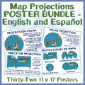
These easy-to-print 11 x 17 map projection signs (16 in English, 16 in Spanish) are great bulletin board resources, interactive notebook content, and teaching props. Many teachers print and use both to introduce language diversity into their classrooms and to support ESOL learners whose native language is Spanish.
The slides in this resource are:
ENGLISH
1-4: The distortion problem and how it connects to map projects
5-8: Mercator, Gore, Interrupted, and Polar projections (title, image, and explanation)
9-12: Mercator, Gore, Interrupted, and Polar projections (title, image, and explanation)
13-16: Identify the projection and use challenge slides
SPANISH
1-4: The distortion problem and how it connects to map projects
5-8: Mercator, Gore, Interrupted, and Polar projections (title, image, and explanation)
9-12: Mercator, Gore, Interrupted, and Polar projections (title, image, and explanation)
13-16: Identify the projection and use challenge slides
I frequently post new resources in English and Spanish so check back regularly!
Follow my blog at www.theworldgeographyguy.com
Follow me on Twitter at https://twitter.com/TeachWorldGeo


