Description
This zip file contains activities (119 pages of student handouts) which can be used to compose a unit on the Earth's Dynamic Crust and Interior. Concepts that are addressed include but not limited to include; location and characteristics of earth layers, earthquake waves, using and s-wave and p-wave travel time graph, finding an epicenter, types of plate boundaries (divergent, convergent and transform) and their characteristics, hazards from earthquakes and volcanoes, earthquake and volcano safety, evidences supporting sea floor spreading, and plate tectonics and supporting evidence. The learning objectives and specific contents of this set of materials is listed below. This set of activities is suited for many earth science, environmental science or physical science classes. With teacher guidance, many components in these materials are adaptable to an enriched middle level science curriculum.
All documents are in PowerPoint, word or pdf format to allow you to edit the documents to meet your needs. Most of the activities in this package of activities are well suited and easily modified for use in distance learning environments. Answer keys for all student activities are provided.
The specific contents of materials in the package are as follows:
- Learning Goals and Objectives (Including NGSS, Common Core and NY State Earth Science Core Curriculum) (3 pp.)
- Earth's Dynamic Crust and Interior Completion Notes (31 pp.)
- PowerPoint to accompany the Completion Notes (includes 6 closure/ticket out activities) (91 slides)
- Virtual Earthquake Lab Activity (5 pp.)
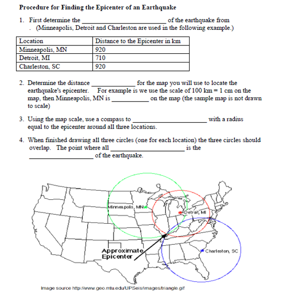
- Finding the Epicenter of an Earthquake Lab (11 pp)
- Earth's Dynamic Crust and Interior Worksheet 1 (52 questions) (11 pp.)
- Earth's Dynamic Crust and Interior Worksheet 2 (43 questions) (14 pp.)
- Faults and Plate Tectonics Worksheet 1 (46 questions) (12 pp.)
- Faults and Plate Tectonics Worksheet 2 (50 questions) (15 pp.)
- Earth's Dynamic Crust and Interior Exam (50 questions) (19 pp.)
- Earth's Dynamic Crust and Interior Jeopardy PowerPoint Game (31 questions) (74 slides)
Learning Standards and Objectives
NGSS Standards: (addressed in whole or in part) HS-ESS1-5., HS-ESS2-1. and HS-ESS3-1.
Common Core State Connections:
ELA/Literacy: WHST 9-12.1, WHST.9-12.2, RST.11-12.1, RST.11-12.8
Mathematics: MP.2, MP.4, HSN-Q.A.2 and HSN-Q.A.3 .
New York State Physical Setting/Earth Science Core Curriculum
Standard 2: Information Systems: Key Idea 3
Standard 6 Interconnectedness: Common Themes Patterns of Change: Key Idea 5
Standard 4: Performance Indicator 2.1: Major Understandings 2.1 j, 2.1 k. 2.1 l, 2.1 m, 2.1 n and 2.1 o
Learning Objectives
Upon the completion of this unit the student will be able to:
1. identify the following given a cross sectional diagram of the earth; lithosphere, crust, moho, asthenosphere, mantle, stiffer mantle, outer core and inner core.
2. briefly describe the following; lithosphere, crust, moho, asthenosphere, mantle, stiffer mantle, outer core and inner core.
3. explain what is meant by original horizontality.
4. describe the following categories of deformed layers; folded, tilted and faulted.
5. explain what is meant by uplifted rock
6. list two evidences supporting the existence of uplifted rock.
7. recognize most earthquakes are associated with faults.
8. explain the difference between the focus and epicenter of an earthquake.
9. explain how different properties of seismic waves provide information about the earth's interior.
10. use an earthquake p-wave and s-wave travel time graph to determine; the travel time of p-waves, the travel time of s-waves, distance to the epicenter of an earthquake and the origin time of an earthquake.
11. determine the arrival time of p-waves and s-waves using a simple seismogram.
12. briefly describe the function of a seismograph.
13. describe the process required to triangulate the epicenter of an earthquake.
14. explain what is meant by the magnitude of an earthquake.
15. briefly discuss the use of the Richter and Mercalli scales.
16. describe five major ways earthquakes may cause damage, injury and/or death.
17. explain what tsunami is.
18. recognize short term prediction of earthquake occurrence is difficult to do.
19. recognize some areas of the world tend to have recurrent earthquakes.
20. recognize many earthquakes and volcanoes occur in similar areas.
21. make five recommendations for preparing for earthquakes.
22. list several ways to increase the chances of surviving an earthquake.
23. explain the basic difference between intrusive and extrusive igneous rock.
24. recognize volcanic eruptions vary in nature and intensity.
25. state five ways a volcano may be a natural hazard.
26. state several safety considerations to take before and during volcanic eruptions.
27. describe where the Ring of Fire is located.
28. recognize it is likely convection currents in the asthenosphere power the movement of crustal plates.
29. interpret the information provided by the inferred properties of the earth reference table.
30. compare the continental and oceanic crust in terms of their thickness and the composition/density of their rocks.
31. explain what the plate tectonic theory is.
32. recognize supercontinents have existed in the geologic past, including Rodinia and Pangaea.
33. recognize plate boundaries are frequently associated with volcanoes, earthquakes and mountain building.
34. explain what is meant by a divergent plate boundary.
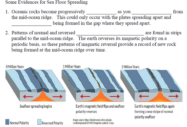
35. recognize divergent plate boundaries are associated with sea floor spreading, mid-ocean ridges and rift valleys on continents.
36. explain how rock age and magnetic polarity provide supporting evidence for sea floor spreading.
37. explain what is meant by a convergent plate boundary.
38. define the term subduction.
39. recognize subduction zones are associated with deep earthquakes, volcanoes and large areas of regional metamorphism.
40. recognize island arcs and ocean trenches are associated with the convergence of two oceanic plates.
41. recognize that continental and oceanic plate convergence will result in the formation of ocean trench off the continent where the plates meet and an adjacent mountain range above the subduction zone on the continental plate.
42. associate the collision of two continental plates tends to form high, young mountains.
43. define the term orogeny.
44. describe the plate movements at a transform boundary.
45. recognize the San Andreas fault is an example of a transform plate boundary.
46. describe what is meant by a hot spot.
47. list two hot spot locations.
48. discuss how continental drift and continental shapes support the theory of plate tectonics.
49. use the fossil and rock record where the continents appear to fit together to support the theory of plate tectonics.
50. utilize a map of tectonic plates and hot spots to identify and interpret geologic features associated with the map.
Terms of Use
Purchase of the product is for classroom use by the purchaser only. It is a violation for individuals, schools, and districts to redistribute or sell this item on the Internet or to other individuals. I do encourage you to use and edit these documents to suit your needs with your own students in distance learning environments.
This work is licensed under a Creative Commons Attribution-NonCommercial-ShareAlike 4.0 International License.


